© Geoff Radcliffe 2011

The Haute Savoie
The Haute Savoie is a beautiful and mountainous area for walking. The walks described are all circular and can be done in a day.
In the files for download, the tracks follow the routes as described in the Cicerone walking guides to Haute Savoie:North and South. I have also included waypoints for the start of many of the walks in these books.
The Walks
Boucle du Lac de Lessy (12.7 km)
A well-signposted switchback walk that goes around a lake.
Cascade d'Angon (7.3 km)
A walk to a spectacular waterfall that gives great views of lake Annecy.
Chalets de Criou (12.3 km)
A shady walk into an unspoiled village.
Circuit des Annes (11.7 km)
A beautiful walk to the Refuge Gramusset that gives good views of Pointe Percee.
Col de Chesery (13.5 km)
A good balcony walk with good views of Lac de Montriond.
Col de Cou (11.9 km)
A beautiful walk that takes you from France into Switzerland.
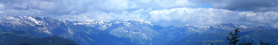
La Haute Pointe (10.4 km)
A walk around a mountain with an ascent to its summit that gives a good panoramic view.
Lac d'Anterne (21.8 km)
A walk which has a long uphill section that takes you to a lake in a beautiful alpine area with views of Mont Blanc. You may also be able to spot several marmots.
Le Mole (9.5 km)
A classic walk that attains the summit of this mountain.
Montagne d'Hirmentaz (10.7 km)
A ridge walk with good views.
Pointe de Chevran (4.8 km)
A short and shady walk that gives good views of Cluses.
Pointe de Marcelly (10.1 km)
A dramatic and airy ridge walk that involves some scrambling up using cables (but this can be avoided).